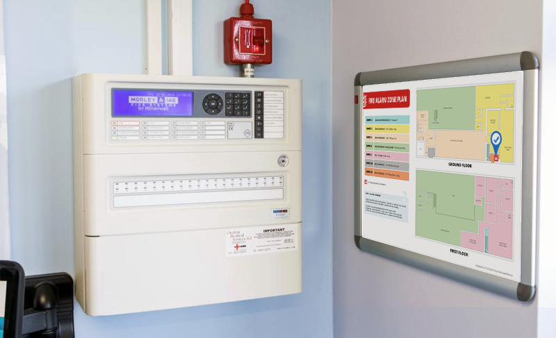
Fire Alarm Zone Charts
A fire alarm zone chart (also called a zone plan or zone map) is a diagrammatic representation of a building showing its division into fire detection zones. We provide fire alarm zone charts that enable a person responding to an alert to quickly match the indicated zone on the control panel with its geographical location within the building. Verification, evacuation and firefighting operations can then be quickly directed to the zone of the alert.The following design parameters should be met for compliance with BS 5839-1:2017 and I.S. 3218:2024:
- The plan should be a simplified drawing of the building's layout and not an architectural or engineering drawing
- The plan should clearly identify the building layout, entrances, stairwells, circulation areas, designated escape routes, and the division of the system into zones
- The plan should be correctly orientated
- The plan should include a ‘You Are Here’ locator icon, so the responder can identify where he/she is located in relation to the indicated zone
- The zones should be clearly identifiable (Individually labelled zones or a legend of colours or both should be used)
- All zones should be shown on the plan
- For remotely monitored systems, the contact number for the Alarm Receiving Centre (ARC)
- Issue date and revision number
- Control and indicating equipment operating instructions or specific procedures, e.g reset


Antrim, Armagh, Carlow, Cavan, Clare, Cork, Derry, Donegal, Down, Dublin, Fermanagh, Galway, Kerry, Kildare, Kilkenny, Laois, Leitrim, Limerick, Longford, Louth, Mayo, Meath, Monaghan, Offaly, Roscommon, Sligo, Tipperary, Tyrone, Waterford, Westmeath, Wexford, and Wicklow